Kancamagus Highway Attractions & Map for 2020
Kancamagus Scenic Highway- Conway NH to Lincoln NH
The Kancamagus Scenic Highway is a top destination for hundreds of thousands of New Hampshire White Mountain visitors each year. The 34 mile road which hugs the pristine cool waters of the Swift River provides visitors with an opportunity to connect with nature first hand by exploring the river, walking on its hiking trails, catching glimpses of the local wildlife, and taking in the breathtaking views from the scenic overlooks. If you are in the area this is a scenic drive that you will not want to miss! 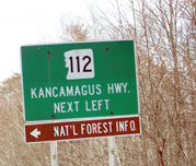 Also known as route 112, the Kancamagus begins at the intersection of Route 16 in Conway NH, wanders thru the White Mountain National Forrest and ends in Lincoln NH where it crosses Interstate 93 and connects to Route 3. While the scenery from your car is truly spectacular, you will not gain the full experience of the area unless you take the time to stop along the way and explore the many trails, waterfalls and other scenic attraction along the roadside. Have fun, be safe, and enjoy!
History
This scenic highway through the NH White Mountain National Forrest was constructed through the combined efforts of the NH Dept. of Public Works & highways, US bureau of public Roads, and the US forest Service. The road was opened between Conway and Lincoln in 1959. The scenic road opens up the Swift River and the East Branch of the Pemigewasset River Watersheds for the public to enjoy . The Kancamagus Scenic Hwy. was named after the Indian Kancamagus (meaning the fearless one), the grandson of Passaconaway, succeeded his uncle, Wonalancet, about 1684 as the 3rd and final “Sagamon” of the Penacook Confederacy. He tried to maintain peace between the Indians and whites, but harassment from the English aggravated this hot-tempered chieftain until he let loose the furies of war, causing much bloodshed. The tribes of the confederacy became scattered and Kancamagus, with his followers, moved to Northern NH or into Canada.
Important Tips
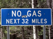 Cell phone service is non-existent once you get a few miles in on the highway. There are no gas stations or convenience stores on the highway. Plan ahead and make sure you have gas and food for your trip. A recreation parking pass is needed (currently $3.00 per day) to park in designated parking areas along the road. All hiking trailheads along the Kancamagus scenic byway require a recreation parking pass. Passes can be purchased at the ranger station as well as self service areas at most of the parking areas. Weekly ($5.00) and annual passes ($20.00) can also be purchased. Daily passes cover entrance to any of the parking areas as well as the Colbath House.
There is no camping or fires allowed within ¼ mile from the roadside. Fireworks are prohibited in the National Forrest. Because of the amount of traffic that can occur in the summer and fall seasons, sometimes the roadway can become a bit congested. There are many places to pull over to view and explore the river, especially in the first 7 miles of the road from Conway towards Lincoln. For everyone’s safety, make sure that your vehicle is parked off the shoulder of the road and do not try to park in areas that do not have an adequate parking shoulder. As the driver of your vehicle it is quite tempting to look at everything around you, due to the beauty of the surrounding scenery. For your safety keep a close eye on the road while driving. A few spots along the road can get a bit narrow. Also keep an eye out for wildlife on the roadway. It is not unusual to spot deer or moose along the side of the road or in the marshy areas . Water levels can vary greatly depending on the season and rainfall. Please take caution when walking along the river and stream banks, as the rocks can be very slippery. Because the water is so clean and clear, pools are often much deeper than they look. There are a total of six National Forrest Campgrounds along the Kancamagus.
The following is a list from Conway end of the roadway to the Lincoln End.
1) Covered Bridge Campground
2) Blackberry Crossing campground
3) Jigger Johnson Campground
4) Passaconaway Campground
5) Big Rock Campground
6) Hancock Campground
Scenic Points of Interest
If you are entering the Kancamagus from Route 16 in Conway here are some of the major scenic points of interest along the roadway. The mileages listed are taken from the Rangers Station which is located on the right hand side of the road Aprox. 1/10 mile from Route 16
-
- (0 mile mark) Ranger Station– There is a parking area with a visitors building which has bathrooms and a visitor information kiosk with an attendant. You can buy parking recreation passes here.
- (6.0 miles on the right) Albany Covered Bridge& Boulder Loop Trail Originally built in 1858 and restored in 1970 the Albany Covered Bridge crosses the Swift River. The parking area is located just outside the entrance to the bridge and has bathrooms and picnic tables. Visitors can cross the wooden bridge and proceed to an area with picnic tables and a fishing area. The trailhead for Boulder loop trail begins opposite the parking lot. The trail is a moderately easy 2.8 mile round trip hike (Approx. 3 hours) which consists of a gradual climb with some steep pitches. The trail offer scenic views of the Swift River and Mount Chocorua.
-
- (7.0 miles on the right) Swift River Lower Falls Definitely one of the most popular spots on the river, the lower falls offers a place for visitors to picnic, sunbathe on the rocks and wade and swim in the river. The parking area has bathrooms with changing rooms. The falls feed into a large pool with a sandy bottom which is great for swimming. The river remains quite cool, even in the middle of the hot summer. The top video was fimed in April when the water flow in the river was at its peak. The bottom video was filmed in July when the river is very accessible to swimmers.
- (7.0 miles on the right) Swift River Lower Falls Definitely one of the most popular spots on the river, the lower falls offers a place for visitors to picnic, sunbathe on the rocks and wade and swim in the river. The parking area has bathrooms with changing rooms. The falls feed into a large pool with a sandy bottom which is great for swimming. The river remains quite cool, even in the middle of the hot summer. The top video was fimed in April when the water flow in the river was at its peak. The bottom video was filmed in July when the river is very accessible to swimmers.
-
- (9.2 miles on the right) Rocky Gorge and Falls Pond Trail The parking area, equipped with bathrooms, feeds a path which leads to the gorge and a bridge which crosses the river. Upstream from the bridge you can view a cascading waterfall as it snakes through a rocky gorge. There are many rocks on the banks of the gorge to sunbathe or view the rapids. Swimming is not allowed in the gorge area. On the other side of the bridge there is a path which leads to Falls Pond, a scenic pond which is a short easy walk from the bridge.
- (9.2 miles on the right) Rocky Gorge and Falls Pond Trail The parking area, equipped with bathrooms, feeds a path which leads to the gorge and a bridge which crosses the river. Upstream from the bridge you can view a cascading waterfall as it snakes through a rocky gorge. There are many rocks on the banks of the gorge to sunbathe or view the rapids. Swimming is not allowed in the gorge area. On the other side of the bridge there is a path which leads to Falls Pond, a scenic pond which is a short easy walk from the bridge.
-
- (10.7 miles on the left) Champney Falls & Mount Chocorua Piper Trail A parking lot without toilet facilities leads you to the Champney falls trailhead. A parking pass is required. Champney Falls ( named after Benjamin Champney- a noted White Mtn. artist (1817-1907) is a series of cascades about 70 feet long. During periods of high water the falls are quite spectacular. During dry spells the falls can become much less impressive. Walking time to the falls and back to the parking lot is about 21/2 hours. The Champney Falls loop is 1.4 miles, while the Piper Trail is located 3.2 miles away. Both the Champney Falls trail and the Piper trail take you to the summit of Mount Chocorua. The Piper trail leads back to Route 16 on the south eastern side of Mount Chocorua.
- (10.7 miles on the left) Champney Falls & Mount Chocorua Piper Trail A parking lot without toilet facilities leads you to the Champney falls trailhead. A parking pass is required. Champney Falls ( named after Benjamin Champney- a noted White Mtn. artist (1817-1907) is a series of cascades about 70 feet long. During periods of high water the falls are quite spectacular. During dry spells the falls can become much less impressive. Walking time to the falls and back to the parking lot is about 21/2 hours. The Champney Falls loop is 1.4 miles, while the Piper Trail is located 3.2 miles away. Both the Champney Falls trail and the Piper trail take you to the summit of Mount Chocorua. The Piper trail leads back to Route 16 on the south eastern side of Mount Chocorua.
-
- (12.7 miles on the right) Russell- Colbath Historic Homestead Site The Russell-Colbath House, on the Kancamagus Highway in Albany, NH, is a 19th century farmhouse with period furnishings which operates as a historic house museum, with an on-site historic interpreter. Visitors can learn about the history of the Passaconaway Valley, the families who lived in the house, domestic life in the 19th century, and view artifacts uncovered in recent archaeological excavations. The house, which is listed on the National Register of Historic Places, is open to the public seasonally. For a PDF printable brochure click here
- (14 miles on the left) Mount Hedgehog Via the UNH Trail This is a moderately difficult loop trail hike which begins at the University Of NH Downes Brook trailhead (across from Passaconaway Campground). The trail climbs to the summit of a 2,500 foot mountain and offers views of the Swift River and the surrounding mountains.
- (15.6 miles on the left) Sabbaday Falls Sabbaday Falls is a favorite place for visitors to stop due to the relatively easy 4/10 mile round-trip journey to the Falls area. The falls consist of a series of cascades flowing thru a narrow flume-like rock formation, cut from glaciers which retreated thousands of years ago during the last ice age. There are handrails on the river side of the trail over the falls area. There is also a picnic area available and bathrooms in the parking lot area. The falls are quite spectacular, especially in periods of heavy water flow.
- (24 miles on the left) Greely Ponds Trail The trail consists of a moderately easy 2-1/2 to 3 hour roundtrip hike of Approx. 5 miles. About a mile from the trailhead, there is a scenic area with views of 2 beautiful ponds, Upper Greely Pond and Lower Greely Pond. Upper Greely pond is a deeper pond surrounded by mountain cliffs and old growth timber. The Lower pond is more typical of a beaver pond. Both ponds offer trout fishing ( a license is required). This is well worth the walk for the scenery.
- (17.6 miles on the right) Sugar Hill Scenic Overlook This scenic overlook (with parking area) boasts panoramic views of Sugar Hill and the surrounding Swift River Valley.
- (21.9 miles ) CL Graham / Wangan Grounds Scenic Overlook This scenic overlook boasts spectacular views from the highest point on the Kancamagus Scenic Hwy. from near the top of Mount Kancamagus at an elevation of 2,855 feet. The top of Mount Kancamagus is the starting point of two rivers which both eventually feed into the Atlantic Ocean. To the East, the Swift River is formed (hugging the Kancamagus Hwy. towards the Conway End of the road) which eventually converges with the Saco River in Conway NH and ends up 130 miles east in Saco Maine where it enters the Atlantic ocean. To the West, the Pemigewasset River is formed which eventually converges with the Merrimack River and dumps into the Atlantic Ocean in Newbury Massachusetts.
- (29 miles on the left) Loon Mountain Ski Area- Lincoln NH
Kancamagus Highway Map
